

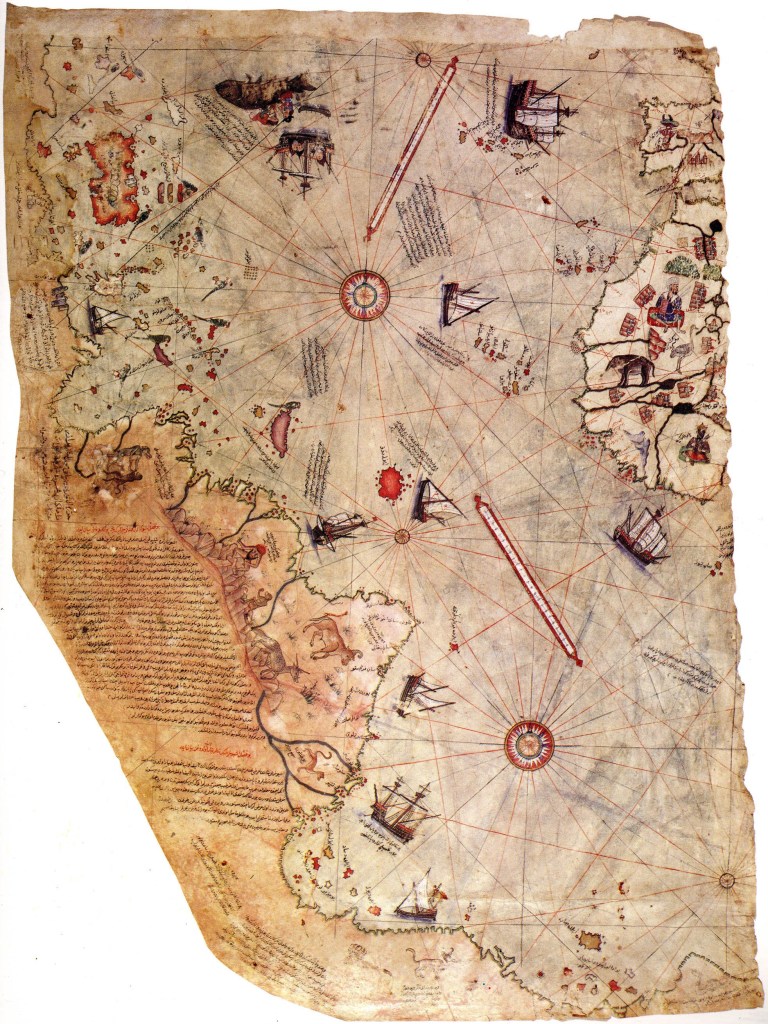
The Piri Reis Map of 1513 is the first surviving map that shows the Americas. It is said to show North America, South America, Greenland and Antarctica. This was surprising since Antarctica had not been discovered until 1820 and somewhat more intriguingly it appears to show the land mass before it was covered in ice, over 6000 years ago. The map showed the outline of South America very accurately. This added to the surprise since Columbus had stumbled upon the New World only 21 years earlier in 1492.
The map, drawn on gazelle skin parchment, was presented to Ottoman Sultan Selim I in 1517. Today only around one-third of the map remains in existence.


Ahmed Muhiddin Piri (Piri Reis) (1470 – 1553) was a famous admiral of the Turkish navy in the sixteenth century. He was considered an expert on Mediterranean lands and coastlines. In 1547, Piri had risen to the rank of Reis (Admiral) as the Commander of the Ottoman Fleet in the Indian Ocean and Admiral of the Fleet in Egypt. He had a passion for cartography and was always searching for new maps and other such documents. Piri Reis was the author of the Kitāb-ı Baḥrīye, or “Book of the Sea”(1), one of the most famous cartographical works of the period.
- or “Book of the Mariner”
The story of the Piri Reis map began in 1501, just nine years after Columbus discovered the New World, when Kemal Reis, a captain in the Ottoman fleet, captured seven ships off the coast of Spain. After interrogating the ships crews he discovered that one man had sailed with Columbus on his great voyages of discovery. More importantly the sailor had in his possession a map of the New World drawn by Columbus himself. Kemal Reis seized the map, kept it and subsequently willed it to his nephew Piri Reis. In 1513 (1) Piri produced a map compiled from antique charts that he owned and from other documents he had access to at the Imperial Library of Constantinople. Many of these documents had survived from the days of the Great Library of Alexandria in Egypt which was destroyed sometime between 200 and 300AD. Notes made by Piri indicated he had based his map on earlier maps, including one consulted by Columbus before his famous voyage (2). This map may have been the Toscanelli chart that was drawn up by the Florentine intellectual Paolo dal Pozzo Toscanelli prior to 1474, decades before Columbus’s journey in 1492. In addition to the Columbus map received from his uncle, Piri stated that he had used 20 different maps and charts as his source documents. Eight of them were Ptolemaic maps (maps of the known world according to the 2nd century Hellenistic or Greek society), four were Portuguese maps and one was an Arabic map. What interests me was the map that Columbus consulted before venturing off into the unknown. Did this map once occupy a shelf in the library at Alexandria? Did it possess the knowledge of ancient seafarers since lost to time? Did Columbus really think he was heading for Asia or did he have a map of the Americas laid out before him and the Asian trip was merely a ruse to cover grander schemes?
- The map bears the date of 919 in the Moslem calendar, which corresponds to 1513 CE in the Western (Gregorian) calendar. The Gregorian calendar was introduced in 1582 by Pope Gregory XIII . It was designed to replace the Julian calendar. The Julian calendar, first implemented by Julius Caesar in 46 B.C. was still currently in use. However, the mathematics designed to calculated the Juliar Solar Year was out by 11 minutes and in the intervening century and a half the seasons had started to fall out of synch with where they sould have sat in the calendar (by more than 2 months).
- From Inscription 6 on the map : From eight Jaferyas of that kind and one Arabic map of Hind [India], and from four newly drawn Portuguese maps which show the countries of Sind [now in modern day Pakistan], Hind and Çin [China] geometrically drawn, and also from a map drawn by Qulūnbū [Columbus] in the western region, I have extracted it. By reducing all these maps to one scale this final form was arrived at, so that this map of these lands is regarded by seamen as accurate and as reliable as the accuracy and reliability of the Seven Seas on the aforesaid maps.”
Piri Reis was beheaded in 1553. The primary reason for his execution was disobedience to the sultan. Apparently he was asked to go to Basra and then to capture the island of Hormuz. Because he didn’t follow through with his orders the Ottomans lost the opportunity to capture this strategic piece of land and as a result they couldn’t access the Indian Ocean via the Persian Gulf. This meant that the Portuguese were able to dominate both the Persian Gulf, the waters of Aden, and the Red Sea thus exposing the holy cities of Mecca and Medina to the threat of Portuguese attack.
The Piri Reis map was discovered on October 9, 1929 by a German theologian named Gustav Adolf Deissmann while he was cataloguing items in the Topkapi Palace Library in Istanbul.
Since its discovery, the map has stirred both intrigue and controversy.
Credit: Wikipedia
