
From intense snowfall and icy easterly winds to heavy downpours, the UK has been battered by a whole host of weather conditions lately.
And now, besides predictions of an upcoming mini-heatwave, forecasters are alerting Brits of a rare phenomenon set to hit the country today.
Weather watchers have been told to keep their eyes towards the sky as an unusual weather event called the "Helm Wind" is on the way.
The strong north-easterly wind is the only named weather of its kind in Britain and is expected to hit the south-west slopes of Cross Fell in Cumbria.
RELATED ARTICLES: Derecho, brumous and mizzle: Ten bizarre weather terms that don't sound real
Seven of the most extreme weather conditions in the solar system
Ten incredibly rare and unusual snow and ice formations
The affects of the rare phenomenon produces unusually-shaped cloud formations and is most common during winter and spring.
According to experts, when the Helm Wind blows a heavy bank of cloud hangs low in the air along or just above the Cross Fell.
But besides 'Helm Wind', what other weird, rare and unusual cloud formations are there in the world, and what is the science behind them?
Click through the images below to have a look at some of our top picks.
MORE: Air mass explained - how will tropical winds lift UK temperatures above average?
1. Lenticularis
These smooth, oval-like shaped clouds, officially named altocumulus lenticularis clouds, are believed to be one of the most common reasons behind sightings of UFOs.
Appearing downwind of mountains, they hover in the sky, even in the wind.
When air travels and comes across an obstacle like a mountain, the air is forced to rise and pass over it. Air then spreads over the other side and gravity causes it to drop slightly before rising back up again.
2. Nacreous clouds
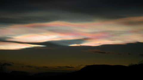
Nacreous clouds are some of the rarest clouds on the planet.
They are a form of polar stratospheric cloud, which is a main culprit in chemical destruction of the ozone layer.
The clouds manifest close to the poles during the coldest of winters; when temperatures plummet below -83C, tiny quantities of moisture in what is usually quite a dry stratosphere condense to create wispy ice crystals clouds.
MORE: April showers: Ten stunning facts about rain to pour over
Since nacreous clouds form in altitudes as high as 15,000m, the sun is always illuminating them where the ice crystals within scatter and diffract light.
However, these multi-coloured clouds increase the chemical reactions that transform benign carbons, called chlorofluorocarbons, into chlorine that is harmful to the ozone.
3. Arcus
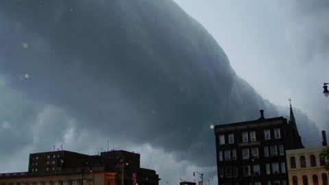
Arcus clouds, otherwise known as roll or shelf clouds, are associated with powerful storm clouds and thunderstorms.
There are two types of arcus clouds, shelf clouds and roll clouds, which can usually be spotted underneath fearsome storm clouds or cumulonimbus clouds.
They need specific weather conditions and the correct amount of moisture in the air to manifest, such as during or just before a storm.
4. Virga
Virga clouds are often described as having a similar appearance to jellyfish and are most noticeable when illuminated by the sun at sunset, with a breeze curving their extended hanging tails.
Virga clouds are formed when trails of rainfall disperse from the underside of a cloud but evaporate before reaching the ground.
5. Mackerel Sky
‘Mackerel sky and mare's tails make tall ships carry low sails’. This proverb originates from a time when cloud formations were used to indicate whether the sails on boats and ships needed to be lowered or not.
Otherwise referred to as simply ‘mackerel sky’, the phrase is linked to altocumulus clouds. While ‘mare’s tail’ makes reference to cirrus clouds.
MORE: Incredible Hawaii lava bubble photo goes viral 49 years later
Both altocumulus and cirrus clouds that make up the mackerel sky formation are known to often develop prior to the instance of a storm - which would lead to sailors lowering their ships’ sails.
When there is a specific level of moisture in the air, altocumulus clouds form, providing an indication that rainfall is drawing closer.
The expression itself, ‘mackerel sky’, derives from the clouds resemblance to the the scales of fish.
6. Mammatus
With an array of lumps and bulges, the mammatus cloud is by far one of the most unusual and distinct cloud formations.
Turbulance within a cumulonimbus cloud will cause mammatus clouds to form.
Cumulonimbus clouds are often otherwise known as thunderstorm clouds, which are very large and usually very unstable. Hail, rain and lightning can all be the result of such unsettled conditions.
7. Fallstreak holes
Often referred to as 'hole-punch' clouds, fallstreak holes can grow as big as 50km in just one hour.
They appear between layers of mid to high level clouds in the sky, when an area of moisture suddenly begins to freeze and fall.
MORE: Summer breeze to make it feel fine for sun-loving Britons
8. Kelvin-Helmholtz wave
Kelvin-Helmholtz wave is an extremely rare weather phenomenon where a cloud creates a dramatic wave pattern.
This distinctive cloud appears when there is a strong vertical layer of pressure between two air streams in the atmosphere, which causes winds to move quicker in high up levels then in lower levels.
It is named after Hermann von Helmholtz and William Thomson Kelvin who were meteorologists who studied unsettled air flow.
9. Cumulonimbus
The cumulonimbus cloud is typically known for being the only cloud to produce hail, thunder and lightning.
They are created through convection, usually developing from small cumulus clouds above a hot surface or along a cold front.
They can grow so big that they appear like a colossal explosion, possessing the energy equivalent to 10 Hiroshima-sized atomic bombs.
NEXT: Stunning places in Britain to enjoy the arrival of Spring (PHOTOS)