ANKARA
By Emre Gurkan Abay - Anadolu Agency
UNESCO has declared 2013 as the “Piri Reis Year” and the life of the influential sailor is being commemorated around the world.
Throughout the year, a number of events in Turkey and around the world underlined the importance of Piri Reis' ideas, works and the impact of his cartography in his era.
Academics from all around the world together with experts presented their studies on the Ottoman admiral, publishing significant articles and books.
Although we still do not know when Piri Reis was born, his influence and legacy in the Ottoman “Golden Age” and the subsequent periods are well documented.
He is universally considered as a foreseeing sailor, and a formidable seadog, spreading terror into the hearts of the Mediterranean rivals of the Ottoman state.
Much of the publication released in the Piri Reis Year, however, focused on the admiral’s another area of expertise: cartography.
In fact, the outstanding ex-pirate was a reputable cartographer and a wise mathematician, whose renowned map is regarded as a work way ahead of its time.
Hajji Ahmed Muhiddin Piri, or as the history writes him; Piri Reis is thought to be born in the mid-15th century, a time when the Ottoman Turks were emerging as a formidable super-power in Europe, heralding “the magnificent century” in which they were the undisputed king of global politics.
His first mission for the Ottoman State was during the evacuation of the Muslims (together with the Jews) from Spain in 1492 after the fall of Granada (Andalusia). He was under the command of Kemal Reis who influenced him throughout their journeys together, teaching Piri most of what he has learned.
“The evacuation of Granada, was valuable for Piri Reis from two aspects” cited Mr. Cevat Ulkekul, who has authored a life story of the Ottoman privateer in 2007.
“First of all, he personally saw the west Mediterranean of which the eastern half was known very well. Then, many experienced sailors and probably some talented cartographers were expelled from the peninsula to find refuge under the Ottoman rule. Columbus discovered the Americas in the same year and the Indian Ocean was reached through the Cape Hope (South Africa) by Vasco de Gama in 1498. Piri Reis was aware of the discoveries and set to work on mapping the known world at his home base in Dardanelles when he was in his 30’s,” said Ulkekul.
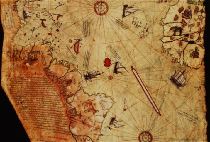
His mastery in mathematics was sophisticated enough to enable him to produce an exceptionally accurate world map in 1513, which provided valuable insights for pirates, buccaneers and seamen of subsequent generations.
Unfortunately that map fell prey to the negligence for centuries until a part of it was re-discovered in 1929. It is surely important to show the level of the science of mapping at the time.
On the other hand, his book, Kitab-ı Bahriye (1526) (The Guide Book of the Seas) was the first and the most correct guide book for the navigation in the Mediterranean and in the Indian Ocean which was used for centuries. It was also a collection of necessary information of population, religion, culture, lifestyle and other related information about people of the shores charted.
“He was not only a good sailor and a talented cartographer, but also a humanist sociologist and scientist who was respectful to the knowledge as well as the references,” added Mr. Ulkekul, emphasizing on the admiral’s attention on the side notes.
The side note quotations on his maps show that he (and his crew) produced all the maps, by integrating the knowledge of the sailors travelling all over the world, adding his talent on the mathematics and the geometry. Some regional charts of distant continents were obtained by purchasing and even spying when necessary. However, advanced level of mathematics, together with the special projection techniques are required to transform the flat patches of charts into a single global map, which Piri Reis and his team had.
englishnews@aa.com.tr
Anadolu Agency website contains only a portion of the news stories offered to subscribers in the AA News Broadcasting System (HAS), and in summarized form. Please contact us for subscription options.
