


In the wonderland of Peru—rediscovering Machu Picchu
The work accomplished by the Peruvian Expedition of 1912, under the auspices of Yale University and the National Geographic Society.
Prof. Hiram Bingham's explorations in South America, 1906-1911, and particularly his discoveries in 1911, were so important that when he was seeking funds for another Peruvian expedition in 1912, the Research Committee of the National Geographic Society made him a grant of $10,000, Yale University contributing an equal amount. His preliminary report to the National Geographic Society and Yale University of the work done in 1912 is printed herewith, and forms one of the most remarkable stories of exploration in South America in the past 50 years. The members of the Society are extremely gratified at the splendid record which Dr. Bingham and all the members of the expedition have made, and as we study the 250 marvelous pictures which are printed with this report, we also are thrilled by the wonders and mystery of Machu Picchu. What an extraordinary people the builders of Machu Picchu must have been to have constructed, without steel implements, and using only stone hammers and wedges, the wonderful city of refuge on the mountain top. —Gilbert H. Grosvenor, Editor
The City of Machu Picchu, the Cradle of the Inca Empire
In 1911, while engaged in a search for Vitcos, the last Inca capital, I went down the Urubamba Valley asking for reports as to the whereabouts of ruins.
The first day out from Cuzco saw us in Urubamba, the capital of a province, a modern town charmingly located a few miles below Yucay, which was famous for being the most highly prized winter resort of the Cuzco Incas. The next day brought us to Ollantaytambo, vividly described by Squier in his interesting book on Peru. Its ancient fortress, perched on a rocky eminence that commands a magnificent view up and down the valley, is still one of the most attractive ancient monuments in America.
Continuing on down the valley over a newly constructed government trail, we found ourselves in a wonderful cañon. So lofty are the peaks on either side that although the trail was frequently shadowed by dense tropical jungle, many of the mountains were capped with snow, and some of them had glaciers. There is no valley in South America that has such varied beauties and so many charms.
Not only has it snow-capped peaks, great granite precipices, some of them 2,000 feet sheer, and a dense tropical jungle; it has also many reminders of the architectural achievements of a bygone race. The roaring rapids of the Urubamba are frequently narrowed by skillfully constructed ancient retaining walls. Wherever the encroaching precipices permitted it, the land between them and the river was terraced. With painstaking care the ancient inhabitants rescued every available strip of arable land from the river. On one sightly bend in the river, where there is a particularly good view, and near a foaming waterfall, some ancient chief built a temple whose walls, still standing, only serve to tantalize the traveler, for there is no bridge within two days' journey and the intervening rapids are impassable. On a precipitous and well-nigh impregnable cliff, walls made of stones carefully fitted together had been placed in the weak spots, so that the defenders of the valley, standing on the top of the cliff, might shower rocks on an attacking force without any danger of their enemies being able to scale the cliff.
The road, following in large part an ancient footpath, is sometimes cut out of the side of sheer precipices, and at others is obliged to run on frail brackets propped against the side of overhanging cliffs. It has been an expensive one to build and will be expensive to maintain. The lack of it prevented earlier explorers from penetrating this cañon. Its existence gave us the chance of discovering Machu Picchu.
On the sixth day out from Cuzco we arrived at a little plantation called Mandorpampa. We camped a few rods away from the owner's grass-thatched hut, and it was not long before he came to visit us and to inquire our business. He turned out to be an Indian rather better than the average, but overfond of "fire-water." His occupation consisted in selling grass and pasturage to passing travelers and in occasionally providing them with ardent spirits. He said that on top of the magnificent precipices nearby there were some ruins at a place called Machu Picchu, and that there were others still more inaccessible at Huayna Picchu, on a peak not far distant from our camp. He offered to show me the ruins, which he had once visited, if I would pay him well for his services. His idea of proper payment was 50 cents for his day's labor. This did not seem unreasonable, although it was two and one-half times his usual day's wage.
Leaving camp soon after breakfast I joined the guide, and, accompanied by a soldier that had been kindly loaned me by the Peruvian government, plunged through the jungle to the river bank, and came to a shaky little bridge made of four tree trunks bound together with vines and stretching across a stream only a few inches above the roaring rapids.
On the other side we had a hard climb; first through the jungle and later up a very stiff, almost precipitous, slope. About noon we reached a little grass hut, where a good-natured Indian family who had been living here for three or four years gave us welcome and set before us gourds full of cool, delicious water and a few cold boiled sweet potatoes.
Apart from another hut in the vicinity and a few stone-faced terraces, there seemed to be little in the way of ruins, and I began to think that my time had been wasted. However, the view was magnificent, the water was delicious; and the shade of the hut most agreeable. So we rested a while and then went on to the top of the ridge. On all sides of us rose the magnificent peaks of the Urubamba Cañon, while 2,000 feet below us the rushing waters of the noisy river, making a great turn, defended three sides of the ridge, on top of which we were hunting for ruins. On the west side of the ridge the three Indian families who had chosen this eagle's nest for their home had built a little path, part of which consisted of crude ladders of vines and tree trunks tied to the face of the precipice.
Presently we found ourselves in the midst of a tropical forest, beneath the shade of whose trees we could make out a maze of ancient walls, the ruins of buildings made of blocks of granite, some of which were beautifully fitted together in the most refined style of Inca architecture. A few rods farther along we came to a little open space, on which were two splendid temples or palaces. The superior character of the stone work, the presence of these splendid edifices, and of what appeared to be an unusually large number of finely constructed stone dwellings, led me to believe that Machu Picchu might prove to be the largest and most important ruin discovered in South America since the days of the Spanish conquest.
A few weeks later I asked Mr. H. L. Tucker, the engineer of the 1911 Expedition, and Mr. Paul Baxter Lanius, the assistant, to go to Machu Picchu and spend three weeks there in an effort to partially clear the ruins and make such a map as was possible in the time at their disposal. The result of this work confirmed me in my belief that here lay a unique opportunity for extensive clearing and excavating.
The fact that one of the most important buildings was marked by three large windows, a rare feature in Peruvian architecture, and that many of the other buildings had windows, added to the significant circumstance that the city was located in the most inaccessible part of the Andes, inclined me to feel that there was a chance that Machu Picchu might prove to be Tampu Tocco, that mythical place from which the Incas had come when they started out to found Cuzco and to make the beginnings of that great empire which was to embrace a large part of South America.
An Ancient Inca Tradition
A story told to some of the early Spanish chroniclers in regard to that distant historical event runs somewhat as follows:
Thousands of years ago there lived in the highlands of Peru a megalithic folk who developed a remarkable civilization, and who left, as architectural records, such cyclopean structures as the fortresses of Sacsahuaman and Ollantaytambo. These people were attacked by barbarian hordes coming from the south—possibly from the Argentine pampas. They were defeated, and fled into one of the most inaccessible Andine cañons. Here, in a region strongly defended by nature, they established themselves; here their descendants lived for several centuries. The chief place was called Tampu Tocco. Eventually regaining their military strength and becoming crowded in this mountainous valley, they left Tampu Tocco, and, under the leadership of three brothers, went out of three windows (or caves) and started for Cuzco. (see Markham's "Incas of Peru," Chapter IV)
The migration was slow and deliberate. They eventually reached Cuzco, and there established the Inca kingdom, which through several centuries spread by conquest over the entire plateau and even as far south as Chile and as far north as Ecuador.
This Inca empire had reached its height when the Spaniards came. The Spaniards were told that Tampu Tocco was at a place called Pacaritampu, a small village a day's journey southwest of Cuzco and in the Apurimac Valley. The chroniclers duly noted this location, and it has been taken for granted ever since that Tampu Tocco was at Pacaritampu.
The Significance of "Windows"
Tampu means "tavern," or "a place of temporary abode." Tocco means "window." The legend is distinctly connected with a place of windows, preferably of three windows from which the three brothers, the heads of three tribes or clans, started out on the campaign that founded the Inca empire.
So far as I could discover, few travelers have ever taken the trouble to visit Pacaritampu, and no one knew whether there were any buildings with windows, or caves, there.
It was part of our plan to settle this question, and Dr. Eaton undertook the reconnaissance of Pacaritampu. He reports the presence of a small ruin, evidently a kind of rest-house or tavern, pleasantly located in the Apurimac Valley, but not naturally defended by nature and not distinguished by windows. In fact, there are neither windows nor caves in the vicinity, and the general topography does not lend itself to a rational connection with the tradition regarding Tampu Tocco.
The presence at Machu Picchu of three large windows in one of the most conspicuous and best-built structures led me to wonder whether it might not be possible that the Incas had purposely deceived the Spaniards in placing Tampu Tocco southwest of Cuzco when it was actually north of Cuzco, at Machu Picchu.
The Incas knew that Machu Picchu, in the most inaccessible part of the Andes, was so safely hidden in tropical jungles on top of gigantic precipices that the Spaniards would not be able to find it unless they were guided to the spot. It was naturally to their advantage to conceal the secret of the actual location of Tampu Tocco, a place which their traditions must have led them to venerate. The topography of the region meets the necessities of the tradition: The presence of windows in the houses might readily give the name Tampu Tocco, or "place of temporary residence where there are windows," to this place, and the three conspicuous windows in the principal temple fits in well with the tradition of the three brothers coming out of three windows.
The interest in this historical problem, connected with the fact that at Machu Picchu we had a wonderfully picturesque and remarkably large well-preserved city, untouched by Spanish hands, led us to feel that the entire place needed to be cleared of its jungle and carefully studied architecturally and topographically.
Difficulties of the Approach to Machu Picchu
We decided to make a thorough hunt for places of burial and to collect as much osteological and ethnological material as could be found. Our task was not an easy one.
The engineers of the 1911 expedition—H. L. Tucker and P. B. Lanius—who had spent three weeks here making a preliminary map, had been unable to use the trail by which I had first visited Machu Picchu, and reported that the trail which they used was so bad as to make it impossible to carry heavy loads over it.
We knew that mule transportation was absolutely impracticable under these conditions, and that it was simply a question of making a foot-path over which Indian bearers could carry reasonably good-sized packs.
The first problem was the construction of a bridge over the Urubamba River to reach the foot of the easier of the two possible trails.
The little foot-bridge of four logs that I had used when visiting Machu Picchu for the first time, in July, 1911, was so badly treated by the early floods of the rainy season that when Mr. Tucker went to Machu Picchu at my request, two months later, to make the reconnaissance map, he found only one log left, and was obliged to use a difficult and more dangerous trail on the other side of the ridge.
Knowing that probably even this log had gone with the later floods, it was with some apprehension that I started Assistant Topographer Heald out from Cuzco early in July, 1912, with instructions to construct a bridge across the Urubamba River opposite Machu Picchu, and make a good trail from the river to the ruins—a trail sufficiently good for Indian bearers to use in carrying our 60-pound food-boxes up to the camp and, later, our 90-pound boxes of potsherds and specimens down to the mule trail near the river.
Some Rapid Bridge Building
At the most feasible point for building a foot-bridge the Urubamba is some 80 feet wide. The roaring rapids are divided into four streams by large boulders in the river at this point. The first reach is 8 feet long, the next nearly 40 feet, the next about 22 feet, and the final one 15 feet.
For material in the construction of the bridge Mr. Heald had hardwood timber growing on the bank of the stream; for tools he had axes, machetes, and picks—all made in Hartford—and a coil of manila rope. For workmen he had 10 unwilling Indians, who had been forced to accompany him by the governor of the nearest town. For "guide, counsellor, and friend" he had an excellent Peruvian soldier, who could be counted on to see to it that the Indians kept faithfully at their task. In describing his work, Mr. Heald says:
"The first step was the felling of the timber for the first two reaches. That was quickly done and the short 8-foot space put in place. Then came the task of getting a stringer to the rock forming the next pier. My first scheme was to lay a log in the water, parallel to the bank and upstream from the bridge, and, fastening the lower end, to let the current swing the upper end around until it lodged on the central boulder. On trying this the timber proved to be so heavy that it sank and was lost.
"We next tried building out over the water as far as we could. Two heavy logs were put in place, with their butts on the shore and their outer ends projecting some 10 feet beyond the first span. The shore ends were weighted with rocks and cross-pieces were lashed on with lianas (sinewy vines), making the bridge about 4½ feet wide, as far as it went. Then a forked upright 10 feet high was lashed and wedged into place at the end of the first pier.
The Crossing Achieved
"A long, light stringer was now pushed out on the completed part and the end thrust out over the water toward rock No. 2, the end being held up by a rope fastened around it and passing through the fork of the upright.
"This method proved successful, the timber's end being laid on the rock which formed our second pier. Two more light timbers were put across this way, and then a heavy one was tried, part of its weight being borne by the pieces already across by means of a yoke locked in the end. This and another piece were successfully passed over, and after that there was little trouble, crosspieces being used to form the next and shorter span.
"On the second day of work we finished the bridge about noon and started making a trail up the hill under the guidance of a half-breed who lived in the vicinity. After the first quarter mile the going was very slow. Not only did the steepness of the slope and the tangled condition of the cane jungle retard us, but the men were very much afraid of snakes, a fear which proved itself justified, for one of them was very nearly bitten by a little gray snake about 12 inches long.
"The second day's work on the trail took us to the city. The path was still far from being finished, though. There were many places which were almost vertical, in which we had to cut steps. Up these places we now made zigzags, so that there was comparatively little difficulty in climbing.
"On the first day I had set fire to the cane in order to clear the trail. This fire did not clear much, however. On the second day I was about a quarter of a mile behind the workmen, or rather above them, when suddenly Tomas (the Peruvian soldier mentioned above), who was with me, said: 'Look, they have fired the cane.' Sure enough, they had started it, and in a minute it had gained headway and was roaring up toward us. The flames reaching 15 or 20 feet into the air.
Escape From Fire in the Jungle
"There was nothing for us but to run, and we did that, tearing through the jungle down hill in an effort to get around the side of the fire. Suddenly on one of my jumps, I didn't stop when I expected to, but kept right on through the air. The brush hall masked a nice little 8-foot jump-off, and I got beautifully bumped. In a minute there came a thump, and Tomas landed beside me. It amused me so much to watch him that I forgot all about my own jolted bones. There was nothing broken, however, and we made our way without much more trouble around the fire and fell upon the peons, who were gathered in a bunch, speculating as to where we might be."
Three days later I reached Machu Picchu in company with Dr. Eaton, our osteologist, and Mr. Erdis, who, as archeological engineer, was to have charge of the general work of clearing and excavating the ruins.
Mr. Heald was at once relieved from further duty at Machu Picchu, where he had just begun the work of clearing, and was asked to see whether he could get to the top of the neighboring peak, called "Huayna Picchu," and investigate the story that there were magnificent ruins upon its summit. The same Indian who had originally told me about the ruins at Machu Picchu had repeatedly declared that those on Huayna Picchu were only slightly inferior. Mr. Heald's report of his work on Huayna Picchu runs in part as follows:
"Huayna Picchu, lying to the north of Machu Picchu, and connected with it by a narrow neck, rises some 2,500 feet above the Urubamba River, which runs around its base. On one side, the south, this elevation is reached by what is practically one complete precipice. On the other, while there are sheer ascents, there are also slopes, and, according to the account of one Arteaga, who claims to have explored the forests which cover a good deal of it, was once cultivated, the slopes being converted into level fields by low earth terraces.
Attempt at Scaling Huayna Picchu
"This mountain is, like Machu Picchu, cut from medium-grained gray to red granite, which accounts in part for its sharp, craggy outlines. The lower slopes, where there are any, are covered with forest growths of large trees. A peculiar thing in this connection is one solitary palm tree, which rises above the other vegetation. Near the top the large trees give place to cane and mesquite, while many slopes have nothing but grass. This last is due more to steepness and lack of soil than to any peculiarity of elevation or location, however …
"My first trip to reach the summit of Huayna Picchu and to ascertain what ruins, if any, were on it, ended in failure. The only man who had been up (Arteaga), who lives at Mandor Pampa, was drunk, and refused to go with me; so I decided to try to find a way without his help. I knew where his bridge crossed the Urubamba River and where he had started up when he went the year before. With these two things to help me, I thought that I could very likely find as much as he had. Accordingly, I started with four peons and Tomas Cobines, the soldier, to have a look.
"The river was passed easily on the rather shaky four-pole bridge, and we started up the slope, cutting steps as we went, for it was almost vertical. About 30 feet up it moderated, however, and, after that, while it was steep, we seldom had to cut steps for more than 20 to 30 feet on a stretch. The greatest hindrance was the cane and long grass, through which it was hard to cut a way with the machetes.
"Our progress, slow at first, got absolutely snail-like as the men got tired; so, getting impatient, I resolved to push on alone, telling them to follow the marks of my machete, and charging Tomas to see that they made a good trail and did not loaf.
"I pushed on up the hill, clearing my way with the machete, or down on all fours, following a bear trail (of which there were many), stopping occasionally to open my shirt at the throat and cool off, as it was terribly hot. The brush through which I made my way was in great part mesquite, terribly tough and with heavy, strong thorns. If a branch was not cut through at one blow, it was pretty sure to come whipping back and drive half a dozen spikes into hands, arms, and body. Luckily I had had enough practice to learn how to strike with a heavy shoulder blow, and for the most part made clean strokes, but I didn't get away untouched by any means.
A Narrow Escape
"Finally, about 3 p.m., I had almost gained the top of the lowest part of the ridge, which runs along like the backplates of some spined dinosaur. The trees had given way to grass or bare rock, the face of the rock being practically vertical. A cliff some 200 feet high stood in my way. By going out to the end of the ridge I thought I could look almost straight down to the river, which looked more like a trout-brook than a river at that distance, though its roar in the rapids came up distinctly.
"I was just climbing out on the top of the lowest 'back-plate' when the grass and soil under my feet let go, and I dropped. For about 20 feet there was a slope of about 70 degrees, and then a jump of about 200 feet, after which it would be bump and repeat down to the river.
"As I shot down the sloping surface I reached out and with my right hand grasped a mesquite bush that was growing in a crack about 5 feet above the jump-off. I was going so fast that it jerked my arm up, and, as my body was turning, pulled me from my side to my face; also, the jerk broke the ligaments holding the outer ends of the clavicle and scapula together. The strength left the arm with the tearing loose of the ligaments, but I had checked enough to give me a chance to get hold of a branch with my left hand.
"After hanging for a moment or two, so as to look everything over, and be sure that I did nothing wrong, I started to work back up. The hardest part was to get my feet on the trunk of the little tree to which I was holding on. The fact that I was wearing moccasins instead of boots helped a great deal here, as they would take hold of the rock. It was distressingly slow work, but after about half an hour I had gotten back to comparatively safe footing. As my right arm was almost useless, I at once made my way down, getting back to camp about 5:30, taking the workmen with me as I went.
"On this trip I saw no sign of Inca work except one small ruined wall …"
Success at the Third Attempt
Five days later Mr. Heald judged that his arm was in sufficiently good shape so that he could continue the work, and he very pluckily made another attempt to reach the top of Huayna Picchu. This likewise ended in failure; but on the following day he returned to the attack, followed his old trail up some 1,700 feet, and, guided by the same half-breed who had told us about the ruins, eventually reached the top. His men were obliged to cut steps in the steep slope for a part of the distance, until they came to some of stone stairs, which led them practically to the summit.
The top consisted of a jumbled mass of granite boulders about 2,500 feet above the river. There were no houses, though there were several flights of steps and three little caves. No family could have wished to live there. It might have been a signal station.
After Mr. Heald had left Machu Picchu we set ourselves to work to see whether excavation in the principal structures would lead to discovery of any sherds or artifacts. It did not take us long to discover that there were potsherds outside of and beneath the outer walls of several of the important structures, but our digging inside the walls of the principal temples was almost without any results whatsoever. We did find that the floor of the principal temple had been carefully made of a mixture of granite gravel, sand, and clay, laid on top of small stones, and these again on top of a mass of granite rocks and boulders. When the temple was in use this clean, white floor must have been an attractive feature.
Our workmen excavated with a will, for the tests made with a crowbar gave such resounding hollow sounds that they felt sure there was treasure to be found beneath the floor of the ancient temple. In places the excavation was carried to a depth of 8 or 9 feet, and practically the entire floor of the temple was excavated to a depth of 3 or 4 feet; but all this back-breaking work ended only in disappointment. There were many crevices and holes between the boulders under the floor, but nothing in them—not even a bone or potsherd.
Digging in the temple of the Three Windows had a similar negative result, but digging outside on the terrace below the three windows resulted in a large quantity of decorated potsherds. Most of them were 2 to 4 feet under the surface. It seemed as though it had been the custom for a long period of time to throw earthenware out of the windows of this edifice. At the end of a week of hard and continuous labor we had not succeeded in finding a single skull, a single burial cave, nor any pieces of bronze or pots worth mentioning. We did not like to resort to the giving of prizes at such an early stage. A day or two spent in hunting over the mountainside with the Indians for burial caves yielding no results, we finally offered a prize of one sol (50 cents gold) to any workman who would report the whereabouts of a cave containing a skull, and who would leave the cave exactly as he found it, allowing us to see the skull actually in position.
The Search for Burial Caves
The next day all the workmen were allowed to follow their own devices, and they started out early on a feverish hunt for burial caves. The half dozen worthies whom we had brought with us from Cuzco returned at the end of the day tattered and torn, sadder and no wiser. They had hewed their way through the jungle, one of them had cut open his big toe with his machete, their clothes were in shreds, and they had found nothing.
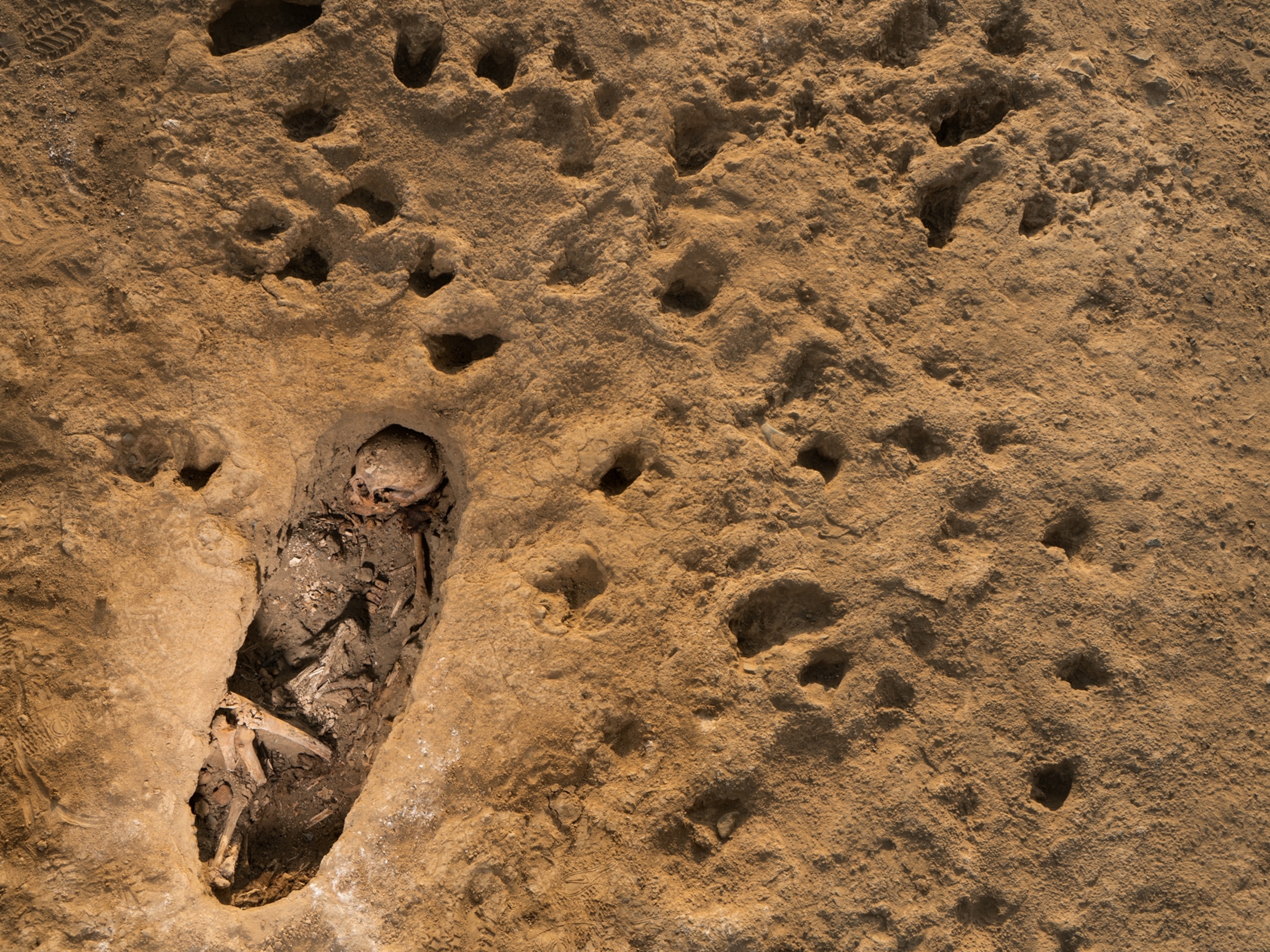
But the Indians who lived in the vicinity, and who had undoubtedly engaged in treasure-hunting before, responded nobly to the offer of a prize, and came back at the end of the day with the story that they had discovered not one, but eight, burial caves, and desired eight soles. This was the beginning of a highly successful effort to locate and collect the skeletal remains of the ancient inhabitants of Machu Picchu. Fifty-two graves in and near this ancient city were excavated by Dr. Eaton, our osteologist, and fully as many more were afterward located and explored under the supervision of Mr. Erdis, the archeological engineer. The greatest number of these graves were in caves under the large boulders and projecting ledges of the mountain side, and the method usually followed by the osteologist in exploring them was, first, to photograph the entrance of the cave from without, after which the grave was opened and its contents carefully removed. Measurements were taken and diagrams were made to show the position of the human skeletons and the arrangement of the accompanying pottery, implements, ornaments, and bones of lower animals.
In a few instances it was possible also to photograph the interiors of graves.
Contents of the Burial Caves
In some of the caves only the most fragmentary skeletal remains were found; in others only the larger bones and a skull or two; while others contained not only nearly complete skeletons, but pots in more or less perfect state of preservation, and occasionally pieces of bronze. In this way a large and valuable collection was made of human skeletons, pottery, and other artifacts of various materials, including some of the tools probably used by the Inca or pre-Inca stone-masons in the more intricate parts of their work.
Before dismissing the subject of the ancient graves, it may be noted that the custom seems to have been, whenever possible, to bury the dead in the sitting position, with the knees raised. In a very few instances bodies were interred in crudely fashioned "bottle-shaped graves." While engaged in this work the collectors were greatly annoyed by the venomous serpents of the region, and several of these serpents were killed and preserved in alcohol.
The burial caves occur generally on the sides of the mountain below the ruins. As they are in well nigh inaccessible locations and more or less covered with dense tropical jungle, the work of visiting and excavating them was extremely arduous, and it is most highly to the credit of those engaged in it that so many caves were opened and so much material gathered. Practically every square rod of the sides of the ridge was explored. The last caves that were opened were very near the Urubamba River itself, where the ancient laborers may have had their huts.
It is too early as yet to give any generalizations with regard to the anatomical characteristics of the Machu Picchu people as evidenced by their skeletal remains. A few of the skulls show decided marks of artificial deformation, but most of them are normal.
Mr. Erdis eventually made the discovery that by digging at least 18 inches underground, at the mouths of small caves, under large boulders, within 200 yards of the Three Window Temple, he was almost sure to find one or two articles of bronze, either pins, tweezers, pendants, or other ornaments.
Selecting two of the most reliable workmen and offering them a sliding scale of rewards for everything they might find of value, he succeeded, in the course of four months' faithful attention to the details of clearing and excavating, in getting together about 200 little bronzes, a lesser number of pots, and 50 cases of sherds. The nature of the more interesting finds can be better understood by the accompanying photograph. This material is now all in New Haven, where it is to be arranged by Dr. Eaton and Mr. Erdis.
What Clearing the Jungle Revealed
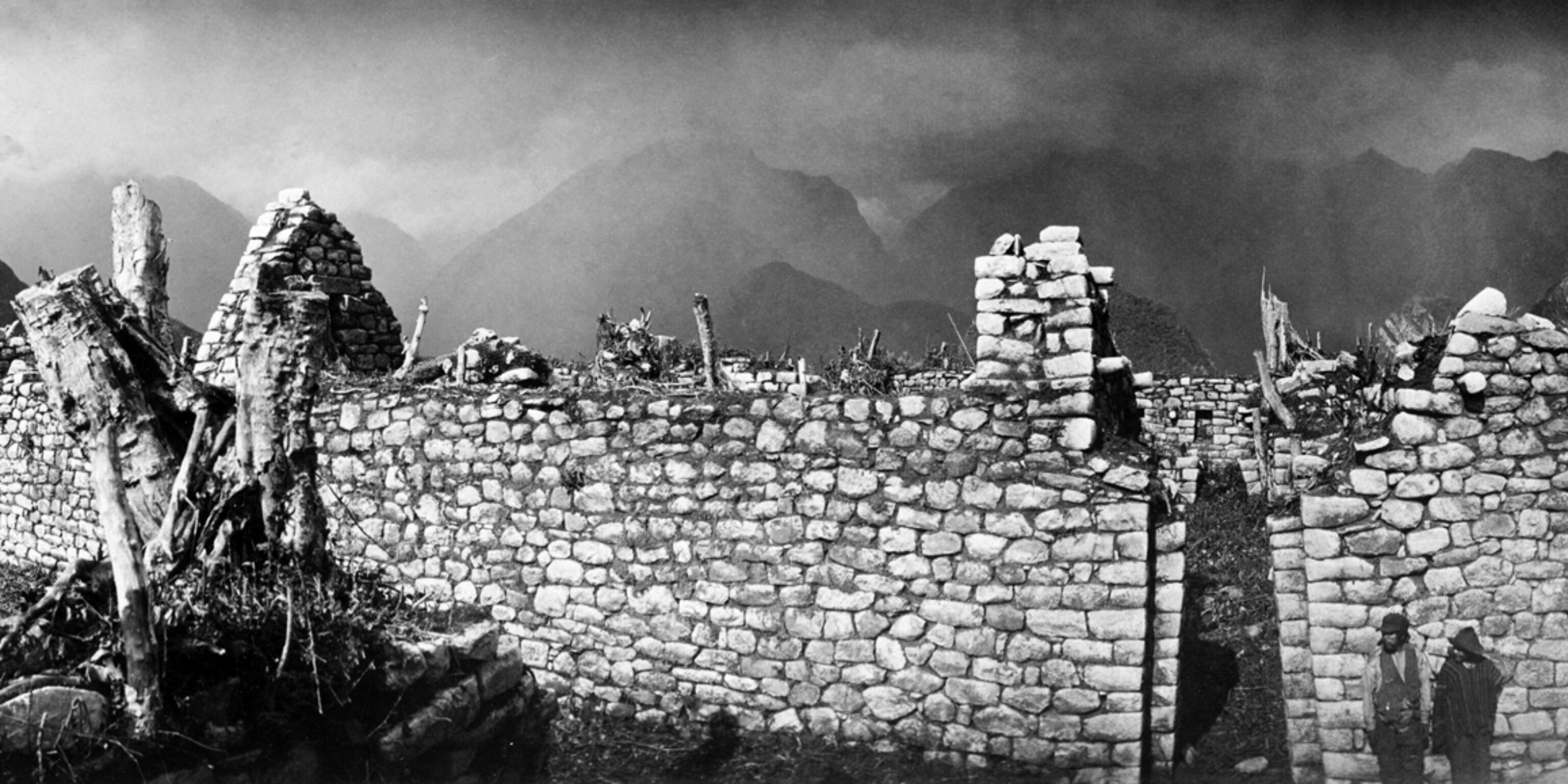
The change made in the appearance of Machu Picchu by the four months of clearing and excavating is graphically brought out by comparing the pictures on pages 404, 424, 432, and 499 with those on pages 433, 434, 490, 498, and 512, the one set taken either before the work began or early in its stages and the latter taken at the end of the season. It is most sincerely to be hoped that the Peruvian government will not allow the ruins to be overgrown with a dense forest, as they have been in the past.
Although the buildings are extremely well built, there is no cement or mortar in the masonry, and there is no means of preventing the roots of forest trees from penetrating the walls and eventually tearing them all down. In several cases we found gigantic trees perched on the very tips of the gable ends of small and beautifully constructed houses. It was not the least difficult part of our work to cut down and get such trees out of the way without seriously damaging the house walls.


Considering all the pains that we took to preserve the ruins from further spoliation by the dense vegetation, it was with frank and painful surprise that we read in the decree issued by the new Peruvian government, in connection with giving us permission to take out of Peru what we had found, a clause stating that we were not to injure the ruins in the slightest particular, and that we must neither deface nor mutilate them. I could not help being reminded of the fact that we had spent two days of one workman's time in erasing from the beautiful granite walls the crude charcoal autographs of visiting Peruvians, one of whom had taken the pains to scrawl in huge letters his name in thirty-three places in the principal and most attractive buildings.
We were greatly aided in the work of clearing the ruins by having with us for two months Lieutenant Sotomayor, of the Peruvian army, whose presence was due to the courtesy of President Leguia. Lieutenant Sotomayor took personal charge of the gang of Indians engaged in clearing the jungle and drying and burning the rubbish. As long as he was allowed to remain with us he did his work most faithfully and efficiently. It was with regret that we found he was relieved from duty at Machu Picchu in September.
An Ideal Place of Refuge
Although it is too early to speak definitely in regard to the civilization of Machu Picchu, a short description of the principal characteristics of the city may not be out of place.
Machu Picchu is essentially a city of refuge. It is perched on a mountain top in the most inaccessible corner of the most inaccessible section of the Urubamba River. So far as I know, there is no part of the Andes that has been better defended by nature.
A stupendous cañon, where the principal rock is granite and where the precipices are frequently over 1,000 feet sheer, presents difficulties of attack and facilities for defense second to none. Here on a narrow ridge, flanked on all sides by precipitous or nearly precipitous slopes, a highly civilized people—artistic, inventive, and capable of sustained endeavor—at some time in the remote past built themselves a city of refuge.
Since they had no iron or steel tools—only stone hammers—its construction must have cost many generations, if not centuries, of effort.
Across the ridge, and defending the builders from attack on the side of the main mountain range, they constructed two walls. One of them, constituting the outer line of defense, leads from precipice to precipice, utilizing as best it can the natural steepness of the hill.
Beyond this, and on top of the mountain called Machu Picchu, which overlooks the valley from the very summit of one of the most stupendous precipices in the cañon, is constructed a signal station, from which the approach of an enemy could be instantly communicated to the city below. Within the outer wall they constructed an extensive series of agricultural terraces, stone lined and averaging about 8 feet high. Between these and the city is a steep, dry moat and the inner wall.
When the members of an attacking force had safely negotiated the precipitous and easily defended sides of the moat, they would still find themselves outside the inner defenses of the city, which consisted of a wall from 15 to 20 feet high, composed of the largest stones that could be found in the vicinity—many of them huge boulders weighing many tons. This wall is carried straight across the ridge from one precipitous side to the other. These defenses are on the south side of the city.
The Town Was Invulnerable
On the north side, on the narrow ridge connecting the city with Huayna Picchu, strong defensive terraces have been strategically placed so as to render nil the danger of an attack on this side. Difficult to reach at best, the city's defenses were still further strengthened by the construction of high, steep walls wherever the precipices did not seem absolutely impassable.
Inside the city the houses are crowded close together, but an extensive system of narrow streets and rock-hewn stairways made intercommunication comfortable and easy.
On entering the city, perhaps the first characteristic that strikes one is that a large majority of the houses were a story and a half in height, with gable ends, and that these gable ends are marked by cylindrical blocks projecting out from the house in such a way as to suggest the idea of the ends of the rafters. The wooden rafters have all disappeared, but the ring-stones to which they were tied may still be seen in some of the pictures.
These ring-stones consist of a slab of granite, about 2 feet long and 6 inches wide by 2 inches thick, with a hole bored in one end, and were set into the sloping gable wall in such a way as to be flush with the surface, although the hole was readily accessible for lashing the beams of the house to the steep pitch of the gables. There were usually four of these ring-stones on each slope of the wall. Dr. Eaton found this to be also a feature of the Choqquequirau architecture, only in that city the number of ring-stones is larger per gable.
A City of Stairways
The next most conspicuous feature of Machu Picchu is the quantity of stairways, there being over 100, large and small, within the city. Some of them have more than 150 steps, while others have but 3 or 4. In some cases each step is a single block of stone 3 or 4 feet wide. In others the entire stairway—6, 8, or 10 steps, as the case might be—was cut out of a single granite boulder.
Again, the stairway would seem almost fantastic, being so narrow and wedged in between two boulders so close together that it would have been impossible for a fat man to use the stairway at all. In no case were the stairways intended for ornament. In every case they are useful in getting to a location otherwise difficult of access.
The largest level space in the city was carefully graded and terraced, so as to be used for agricultural purposes, on the products of which the inhabitants could fall back for a time in case of a siege.
It seems probable that one reason why the city was deserted was a change in climate, resulting in scarcity of water supply. At the present time there are only three small springs on the mountainside, and in the dry season these could barely furnish water enough for cooking and drinking purposes for 40 or 50 people. There could never have been very much water here, for the azequias, or water channels, are narrower than any we have ever seen anywhere else, being generally less than 4 inches in width.
The Fountains on the Stairway
We were able to trace the principal azequia from the vicinity of the springs along the mountain-side for a distance of perhaps a mile, across the dry moat on a slender bridge, then under the city wall, along one of the terraces, and finally to the first of a series of fountains or baths, located on the principal stairway of the city.
This stairway is divided to admit the entrance of one of the fountains, of which there are 14 or 15 in the series. Each basin is about 2½ feet long by 1½ feet wide and from 5 to 6 inches in depth. In some cases the basin and the floor of the bath-house, or fountain, is made of a single slab of granite. Generally holes were drilled in one of the corners of the basin to permit the water to flow through carefully cut underground channels to the next basin below.
The Peruvians call these fountains "baths." It does not seem to me likely that they were used for this purpose, but rather that, by a careful husbanding in basins of this sort, the water-pots of the inhabitants could the more readily be filled by any one coming to one of the fountains. Many of the houses are built on terraces on the steep sloping hillsides. In such case their doors face the hill and the windows look out on the view. Most of the houses are well provided with niches, the average size being about 2½ feet in height by 1¼ feet in width. In some interiors projecting cylindrical blocks are found alternating between the niches. In a few houses we found evidence of stucco, but in most cases the mud plaster had entirely disappeared.
Possibly the most interesting conclusion brought out as a result of our extensive clearing and excavating is that the city was at one time divided into wards or clan groups. Each one of these groups has but one entrance, a gateway furnished with the means of being solidly fastened on the inside. None of the doors to houses or temples have this locking device, but all the entrances to the clan groups have it, and the same device occurs in the principal gate to the city.
Ingenious Bolting of the Gates to the Clan Groups
The doors have disappeared, but probably consisted of rough-hewn logs of hard wood. They seem to have been fastened by two bars crossed at right angles. The upright bar was probably tied at the top to a ring-stone set in the wall and projecting from it above the stone lintel of the doorway. It could have been fastened at the bottom by being set into a shallow hole in the ground. The cross-bar was lashed to stone cylinders about 6 inches high and 3 inches in diameter, set into lockholes in the door-posts.
This ingenious device varies in different groups, but in general the principle is the same. The more common method of making these locks was to cut a hole out of the top or corner of one of the larger blocks in the door-posts and set the stone cylinder into saucer-shaped depressions below and above. Thus the cylinder would be so firmly keyed into the wall that it would be able to resist at least as much pressure as the hardwood cross-bar which was lashed to it.
Each one of the clan groups has certain distinctive features. In one of them, characterized by particularly ingenious stone-cutting, the lock-holes were cut in the center of solid granite rectangular blocks. The picture on page 471, taken after the top block had been removed, shows the saucer-shaped depression cut into the upper stone. It also explains how the ingenious architect had carved the cylindrical block and the lock-hole all out of one piece, thus making it much stronger than the average.
Granite boulders in the floor of the principal house in this group had their tops carved into kitchen utensils for grinding corn and frozen potatoes. In this group also we found the only case of houses lined with stucco or plaster made of red clay, and here is the only gabled building divided into two parts by a party wall rising to the peak and pierced by three windows.
Some Exquisite Stonework
Another group was distinguished by having its own private gardens on terraces so arranged that access to them could be had only by passing through the small collection of houses constituting this particular clan group. In another case, the entrance to a group notable for its very elaborate and exquisitely finished stonework, the upright cylinder in the lock-hole is brought flush with the surface of the stone and is a part of the block itself.
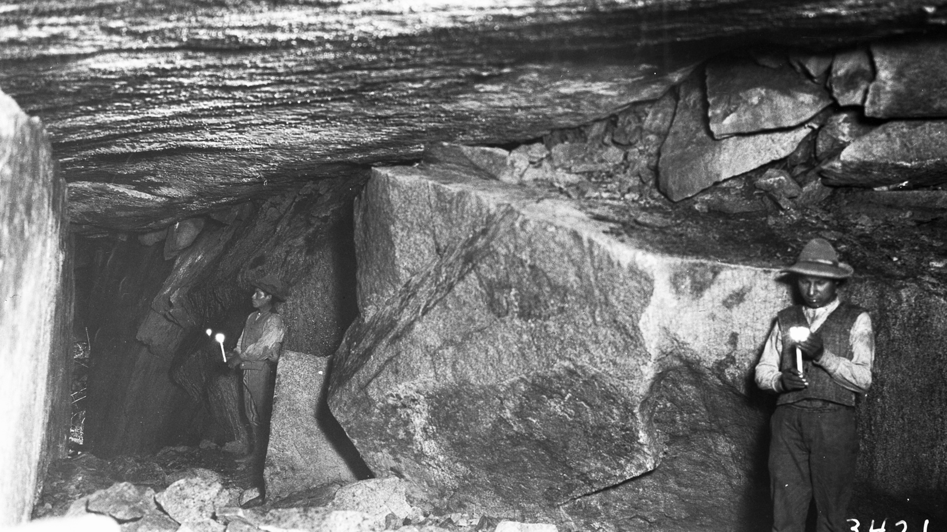
Another group is distinguished by having monolithic lintels for the doorways. In this group also the gables are unusually steep. Nearly all the groups had what seemed to be a religious center, consisting of a more or less carved granite block in position. In several cases caves had been excavated under these rocks, and in one case the cave was beautifully lined with finely cut stonework. In this last cave a semicircular tower was constructed on the top of a boulder and connected with it by the finest example of masonry in Machu Picchu.
This beautiful wall was made of specially selected blocks of beautifully grained white granite, and was constructed by a master artist. We grew more fond of this wall the longer we knew it, and every time we saw it it gave us a thrill of joy.
The detailed study of where the wall joins the next house wall shows how ingeniously the blocks were constructed, so as to form a brace which would prevent the house and wall from leaning apart and thus causing cracks to appear in the wall. The precision of line, the symmetrical arrangement of the blocks, and the gradual gradation in the tiers, with the largest at the bottom and the smallest at the top, combine to produce a wonderfully beautiful effect.
As will be seen from the photograph, the wall is not perpendicular, but inclines inward at the top. This angle is characteristic of nearly all the vertical lines in the ruins. Doors, windows, and niches are all narrower at the top than at the bottom.
In the semicircular tower which connects with this fine wall the ingenious cutting of stones in such a way as to follow a selected curve reaches a perfection equaled only in the celebrated wall of the Temple of the Sun (now the Dominican Monastery), in Cuzco. Like that, it is a flattened curve, not round.
One of the windows in this tower has several small holes near the bottom. These were found to connect, by very narrow channels, barely large enough for a snake to crawl through, with circular holes within the wall, where the snakes might have constructed their nests.
There are still many snakes at Machu Picchu. There are also snakes carved on several rocks. Lizards are not common, and the holes within the wall are much too large for lizards' nests; but they are of the right size for a comfortable snake's nest—for a small snake.
It seems to me possible that in this wall the priest of this clan group kept a few tame snakes and that he used their chance exits out of one hole or another as a means of telling omens and possibly of prophesying.
The so-called sacred plaza is the site of two of the finest structures at Machu Picchu. One of these—the Temple of the Three Windows—has already been referred to; the other is a remarkable structure, about 12 feet in height, built around three sides of a rectangle some 30 feet long and 18 feet wide. A description is hardly necessary, as a better idea can be gained from the pictures than from any words of mine. Suffice it to say that it is marked by a very pleasing symmetry, by the use of tremendous blocks of granite, three of them being over 12 feet in length, and by the projection in an obtuse angle of the ends of the sides.
The Place to Which the Sun Is Tied
On top of the beautifully terraced hill, behind this temple, is a stone, generally agreed to be an intihuatana stone, or sun-dial—the intihuatana being the "place to which the sun is tied." Similar stones were found by the Spanish conquerors in Cuzco, Pisac, and Ollantaytambo. An idea of this stone may be gained from the picture on page 509.
Owing to the location of Machu Picchu in this extremely inaccessible part of the Andes, to its clearly having been a city of refuge, easily defended and suited for defensive purposes; owing to the presence of a large number of windows in the ruins, and particularly to the presence of three large windows in one of the principal temples, I believe it to have been the original Tampu Tocco, from which the Incas came when they started on that migration which led them to conquer Cuzco and to establish the Inca Empire.
The difficulties of life for several centuries in the Vilcabamba region would have been likely to have developed this ingenious and extremely capable race and given them strength of character. The influence of geographical environment is no small factor in developing racial characteristics. I hope at no distant future to prepare an exhaustive report of this wonderful city, whose charm can only dimly be realized from these pictures.
The beautiful blue of the tropical sky, the varying shades of green that clothe the magnificent mountains, and the mysterious charm of the roaring rapids thousands of feet below cannot be portrayed and can with difficulty be imagined.
The Panoramic View
The beautiful panoramic view of Machu Picchu, which accompanies this article as a Supplement, gives a good idea of the grand Cañon of the Urubamba as seen from Machu Picchu, of the sacred Plaza, and Intihuatana Hill, and of the East City.
Unfortunately, it was impossible to take a picture that would also include the other half of Machu Picchu, including the remarkable Upper City, with its rows of houses, each one on a separate terrace, the beautiful buildings of the Princess Group, and the splendid stonework of the King's Group. All of these are behind and to the right of one looking at this panorama. And still further behind are the agricultural terraces, our camp, and Machu Picchu Mountain; but these are all shown in separate views.
The Incas were, undeniably, lovers of beautiful scenery. Many of the ruins of their most important places are located on hill tops, ridges, and mountain shoulders, from which particularly beautiful views can be obtained.
Remarkable as is the architecture of Machu Picchu, and impressive as is the extent of the stone-cutting done by a people who had no steel or iron tools, neither of these things leaves more impression on the mind of the visitor than the inexpressible beauty and grandeur of the surroundings.
A reconnaissance of the forestration of the immediate vicinity and a large scale map of Machu Picchu and its vicinity were made by Assistant Topographer Stephenson. From the map we hope some day to be able to construct a model which will give those not fortunate enough to visit this marvelous place some idea of its character and beauty.
Forestration of the Region
In regard to the forestration of the region, Mr. Stephenson reports that tree growth begins about midway between the source and the mouth of the Urubamba River. Forests frequently interrupted by open areas occupy the lower half of the valley. The open bottoms are moist, untimbered, and used for agriculture. In these the soil is a deep sandy loam, rich in humus and having abundant moisture.
The valley is very narrow, with many tributaries, and rough precipitous sides frequently broken by cliffs. The lower slopes have fairly rich soil and abundant moisture. They extend for several hundred feet above the river. Above them the soil is regularly dry and poor. Although rainfall is abundant, the sunny north slopes have a dry rocky soil.
The forest in the Machu Picchu region is made up of subtropical hard woods, with probably more than 30 species in the stand. Good growth is confined to the valley bottoms and the lower slopes. On the shaded slopes the forest sometimes extends to a point 2,000 feet above the river, and in narrow, protected valleys even higher; but on the upper slopes the trees are of poor form, gnarled and stunted.
On the ridges some trees occur, but they are very scrubby and do not form a canopy. Timber-line here is at elevation of about 10,000 feet above sea-level. The elevation of the river near Machu Picchu is about 6,500 feet above sea-level.
Owing to the large number of species, the quality of the timber varies greatly. Many of these species produce hard, durable wood of fine texture that takes good polish. Other quick-growing species produce woods of inferior quality—soft, brittle, quickly decaying, and of little value for anything but rough lumber.
Notes on the Timber
All species are infected with parasites and all ages of trees seem to be subject to them. The worst damage is done to the fast-growing young trees.
In the bottoms the trees are tall, clean, and straight, running up to over 100 feet in height and 3 feet in diameter. The average is about 18 inches in diameter and 80 feet in height. On the lower slopes the growth is more uniform, with a slightly lower average size. There are a few healthy patches of timber, but they are only of occasional occurrence and limited to a few areas.
The timber in the valley bottoms averages 5,000 board-feet per acre, with a maximum of 10,000 over limited areas. On the slopes the average is 3,000 board-feet, with little variation. These are conservative ocular estimates.
The rugged character of the country makes logging of any but timber in bottoms impracticable. Trails are few and very bad; labor is scarce and uncertain. Should a railroad enter the valley as planned it will be possible to carry on profitable logging operations with portable mills. There is a good supply of timber for ties.
The next thing to be done would be to make a collection of samples, so that the qualities of the various hardwoods might be tested. Such tests would bring out definite facts about their value. Some of them are undoubtedly woods of high technical qualities as well as of beautiful grade and color.
Mr. Stevenson's map of Machu Picchu, the result of a three months' survey, is on a scale of 1 inch = 20 feet, with a contour interval of 10 feet, and consists of 16 large sheets. It should prove very useful in helping us to gain a correct idea of this wonderful city, which seems to have escaped the notice of the Spanish conquerors and to have remained practically unknown until it was first visited by the present writer in July, 1911.
Other Important Inca Ruins
It is still too early to make definite statements in regard to the importance of this discovery; in fact, such opinions can only be passed by archaeological experts after the full report of the work at Machu Picchu has been prepared and published. This much, however, can be said in regard to the superiority in extent and interest of Machu Picchu over previously discovered Inca ruins:
The most important Inca ruins heretofore discovered are in the city of Cuzco, the town and fortress of Ollantaytambo, Pisac, and on the islands of Lake Titicaca. There are, besides these, on the coast a number of localities like Pachacamac, Nazca, Ancon, Trujillo, and the country of the Grand Chimu, where the chief interest lies in the extensive findings of mummies, pottery, textiles, and metal ornaments, including gold, silver, bronze, etc. All of these places, however, were known to the Spanish Conquerors, and have been ransacked by treasure hunters from the earliest times.
Cuzco, the most important place of all, was adopted by the Spaniards as their most important city outside of Lima. They entirely remade the city, using large quantities of the ancient Inca walls to build their own palaces and churches. Although the city still has many Inca remains and retains a great charm for the tourist and the archaeological student, it is more of a Spanish colonial city than of an Inca city. The same is partly true of Ollantaytambo. The ruins of Pisac and many others in the vicinity, of which it is not necessary to give an account here, have repeatedly been ransacked by treasure hunters. The long palace at Vitcos, identified in 1911 as the last Inca capital, has been almost completely destroyed by these treasure hunters. Of the 30 beautiful door of cut granite, only two or three remain intact.
Why Machu Picchu Is an Archeological Treasure
On the other hand, Machu Picchu not only is larger and contains more edifices than any other ruin discovered in Peru (except Cuzco); it has the additional advantage of not having been known to the Spaniards, of not having been occupied by their descendants, and of not having been torn to pieces by treasure hunters seeking within the walls for the gold and silver ornaments that were not to be found in the floors.
In other words, Machu Picchu is not only more extensive than any previously discovered Inca city outside of Cuzco, but it is in a remarkably good state of preservation, and its architecture has not become confused with Spanish efforts to build churches and villas.
If the theory here propounded is correct—that Machu Picchu was the original "Tampu Tocco," from whose "three windows" set out the tribes that eventually founded Cuzco—the importance of Machu Picchu as the cradle of the later Inca race will, of course, be increased.
It is not very profitable to speculate on the habits of these ancient people until we have had more opportunity to study the finds made in the burial caves and to compare these with finds made in other parts of Peru. We know that they were masters of the art of stone-cutting.
We know that they knew how to make bronze, and that they had a considerable artistic sense, as evidenced by their workmanship. One of the bronze pins found at Machu Picchu has for a head a miniature reproduction of the head of a humming-bird, including a long, curved bill. One bronze knife is decorated with the head of a llama; another with an Indian boy, lying on his stomach, with his heels in the air, playing tug-of-war with a large fish on the end of a little bronze rope.
The workmen of Machu Picchu not only had skill, but originality and ingenuity. Their pottery is varied in form and attractive in its ornamentation. They understood how to plan great architectural and engineering works and to carry them to a satisfactory conclusion.
The soil of the terraces is extremely fertile, and the Incas utilized every square yard of available land within a radius of several miles. The two or three Indian families who have been living at Machu Picchu for the past four or five years have had no difficulty in raising good crops of sweet potatoes, corn, peppers, onions, tomatoes, and certain native vegetables unknown in this country. The only difficulty they have found is in keeping down the superabundant tropical vegetation, which constantly threatens to suffocate their crops.
As an instance of how rapidly this vegetation grows, terraces covered by bamboo cane which we cleared in September had to be recleared in November, when most of these pictures were taken. In the intervening two months some of the cane had attained a height of five feet.
It is my hope to prepare a special monograph on Machu Picchu for publication by the National Geographic Society.
Related Topics
You May Also Like


Go Further
Animals
- What La Palma's 'lava tubes' tell us about life on other planetsWhat La Palma's 'lava tubes' tell us about life on other planets
- This fungus turns cicadas into zombies who procreate—then dieThis fungus turns cicadas into zombies who procreate—then die
- How can we protect grizzlies from their biggest threat—trains?How can we protect grizzlies from their biggest threat—trains?
- This ‘saber-toothed’ salmon wasn’t quite what we thoughtThis ‘saber-toothed’ salmon wasn’t quite what we thought
- Why this rhino-zebra friendship makes perfect senseWhy this rhino-zebra friendship makes perfect sense
Environment
- What La Palma's 'lava tubes' tell us about life on other planetsWhat La Palma's 'lava tubes' tell us about life on other planets
- How fungi form ‘fairy rings’ and inspire superstitionsHow fungi form ‘fairy rings’ and inspire superstitions
- Your favorite foods may not taste the same in the future. Here's why.Your favorite foods may not taste the same in the future. Here's why.
- Are the Great Lakes the key to solving America’s emissions conundrum?Are the Great Lakes the key to solving America’s emissions conundrum?
- The world’s historic sites face climate change. Can Petra lead the way?The world’s historic sites face climate change. Can Petra lead the way?
History & Culture
- Hawaii's Lei Day is about so much more than flowersHawaii's Lei Day is about so much more than flowers
- When treasure hunters find artifacts, who gets to keep them?When treasure hunters find artifacts, who gets to keep them?
- Meet the original members of the tortured poets departmentMeet the original members of the tortured poets department
- When America's first ladies brought séances to the White HouseWhen America's first ladies brought séances to the White House
Science
- Should you be concerned about bird flu in your milk?Should you be concerned about bird flu in your milk?
- Here's how astronomers found one of the rarest phenomenons in spaceHere's how astronomers found one of the rarest phenomenons in space
Travel
- Are Italy's 'problem bears' a danger to travellers?Are Italy's 'problem bears' a danger to travellers?
- How to navigate Nantes’ arts and culture scene
- Paid Content
How to navigate Nantes’ arts and culture scene - This striking city is home to some of Spain's most stylish hotelsThis striking city is home to some of Spain's most stylish hotels
- Photo story: a water-borne adventure into fragile AntarcticaPhoto story: a water-borne adventure into fragile Antarctica
